
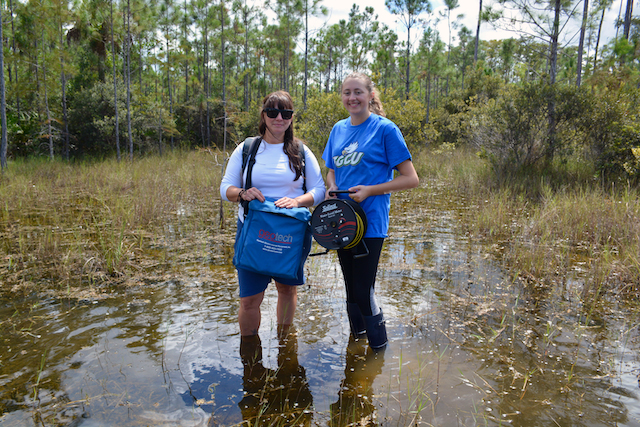
Environmental geology major Jasmine Morejon and a team of researchers at Florida Gulf Coast University have found a way to bring more clarity by studying the past to determine patterns of change.
“Identifying the relationships between groundwater salinity and vegetation helps to reconstruct the past and predict freshwater availability for humans and vegetation which is critical for coastal management,” Morejon said.
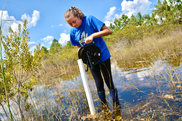
New research findings indicate an increasing rate and impact of saltwater intrusion, or the mixture of saltwater and freshwater, happening along Cayo Costa, a barrier island in Southwest Florida. “We take measurements over time to determine the changes in pH, salinity, temperature and conductivity of the freshwater and we look at satellite imagery and compare shifts in the coastline.”
The team is focused on the unique landscape of Cayo Costa because it is among one of the few barrier islands in Florida that is largely undeveloped. Much of its landscape has been protected and operated as a state park and contains nine miles of sandy shoreline and a collection of pine forests, oak-palm hammocks and mangrove estuaries.
Over the course of two trips out to the remote environment, first in May 2021 and then in July, the findings showed an increase in the saltwater further inland and in various fauna habitats that require freshwater to survive.
“As you walk away from the beach toward other plant habitats, we discovered that the saltwater is mixing with the freshwater, creating brackish water that effects the growth of certain plants like sea grapes,” Morejon said. “These plants are critical for wildlife on the island, but also for protection from storms and rough weather.”
Starting out with a marine science track, Morejon quickly discovered the intersection of water with geology, or hydrogeology, and moved toward that path for her studies. Recently adding a minor in climate change, she is interested in all aspects of water, which is why she chose FGCU to pursue her goal of protecting it. “I visited for a tour and as soon as I stepped into the lab, I could really see myself conducting research here,” Morejon said. “Then I found out about The Water School, and I knew I wanted to be at FGCU.”
Assistant Professor of Geology in the Department of Marine and Earth Sciences, Rachel Rotz PhD, is Morejon’s mentor. With specialties in integrated and interdisciplinary approaches to researching water issues, Rotz recently helped build the environmental geology program at FGCU and shares the benefits of Morejon’s early research endeavors.
“The opportunity to participate in research at an undergraduate level opened doors for Jasmine to pursue a path in STEM, which then encouraged her to put the time in and tackle some of the more challenging courses,” Rotz said. “Interdisciplinary approaches to investigating water inspires students across disciplines to pursue the geosciences and make local connections to water and sustainability issues.”
The coastal research findings at Cayo Costa are so compelling that Morejon was recently chosen to present it at the Geologic Society of America (GSA) annual conference in Portland, Oregon, receiving a full scholarship from the GSA for travel.
Also a recent recipient of The Water School Scholarship in the spring semester for her work on sea-level studies and an award for the Seidler Summer Research Fellowship, Morejon sees no signs of slowing her hydrologic research down. Tracking the data over time is providing the answers to tough issues around predictability of sea level rise and saltwater inundation.
Describing the significance of the research, Rotz focuses on the information gained to help planning and safety in communities across Florida. “Barrier island groundwater and vegetation are vulnerable due to saltwater intrusion by storm surges,” Rotz said. “Water encroaches, vegetation dies and destabilizes the sand, making the barrier island more susceptible to erosion in a storm.”
This was especially evident when the team went back to track the results of changes in July after Tropical Storm Ida. There was significant variation in the amount of salinity in the areas not used to that mixture. The long-term effects on the plants are not yet known, but their susceptibility and adaptation could provide clues to how we all adapt moving forward.
Conversations around protection are becoming increasingly important as climate change starts to impact the future viability of communities throughout Florida.
“Measuring the rate of intrusion is significant on numerous levels of sustainable and healthy communities as we all look at rising populations in Florida,” Rotz said. “Determining the pace of these changes in coastal erosion will inform all of us and provide for better resource planning.”
Incremental measurements can explain big questions regarding when and how long we have to adapt to the changing climate. Paying attention to those variations through research like Morejon’s will help determine efficient and sustainable planning for real estate, business, tourism and healthcare for the Southwest Florida community in the coming century.[/vc_column_text][vc_gallery type=”image_grid” images=”28894,28893,28895,28892″ title=”Measuring saltwater intrusion on Cayo Costa”]